
Íomhá:B26055943A - A map of the East-Indies and the adjacent countries.jpg

Size of this preview: 800 × 509 picteilín. Other resolutions: 320 × 204 picteilín | 640 × 407 picteilín | 1,024 × 652 picteilín | 1,280 × 815 picteilín | 2,560 × 1,629 picteilín | 7,509 × 4,779 picteilín.
Taispeáin leagan ardtaifigh den íomhá (7,509 × 4,779 picteilín, méid comhaid: 12.73 MB, cineál MIME: image/jpeg)
| Seo comhad as An Cómhaoin Viciméid. Tá an tuairisc as an leathanach tuairisc Cómhaoin a leanas thíos.
|
Achoimriú
| Tuairisc |
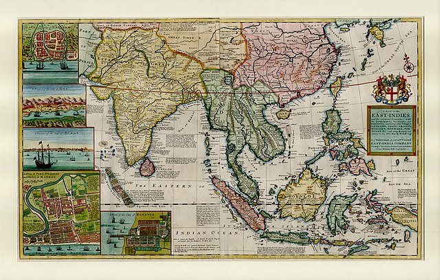
English: This large map by Herman Moll shows the East Indies from the Persian border to New Guinea and the southern part of Japan, including India, Ceylon, southeast Asia, most of China, Indonesia and the Philippines. It illustrates the extent of European influence and trade in the region, at the height of European colonial control. Further map features and detail maps of interest: Batavia, Goa, Mughal Empire, Maldives, Chennai, Banten, Lake Chimay |
| Dáta | |
| Foinse | NLB Singapore, David Parry Southeast Asian Map Collection. Available on BookSG https://eresources.nlb.gov.sg/printheritage/detail/3957ca10-8863-4f87-9d8c-49cfe590b0cd.aspx |
| Údar | Moll, Herman, -1732 |
| Leaganacha eile |


Ceadúnú
| This file is made available under the Creative Commons CC0 1.0 Universal Public Domain Dedication. | |
| The person who associated a work with this deed has dedicated the work to the public domain by waiving all of their rights to the work worldwide under copyright law, including all related and neighboring rights, to the extent allowed by law. You can copy, modify, distribute and perform the work, even for commercial purposes, all without asking permission.
|
Stair chomhaid
Cliceáil ar dáta/am chun an comhad a radharc mar a bhí sé ag an am sin.
| Dáta/Am | Mionsamhail | Toisí | Úsáideoir | Nóta tráchta | |
|---|---|---|---|---|---|
| faoi láthair | 05:13, 28 Nollaig 2021 | | 7,509 × 4,779 (12.73 MB) | NLSingapore | Uploaded a work by Moll, Herman, -1732 from NLB Singapore, David Parry Southeast Asian Map Collection. Available on BookSG https://eresources.nlb.gov.sg/printheritage/detail/3957ca10-8863-4f87-9d8c-49cfe590b0cd.aspx with UploadWizard |
Úsáid comhaid
Tá nasc chuig an gcomhad seo ar na leathanaigh seo a leanas:
Global file usage
The following other wikis use this file:
- Úsáid ar ar.wikipedia.org
- Úsáid ar ast.wikipedia.org
- Úsáid ar az.wikipedia.org
- Úsáid ar be.wikipedia.org
- Úsáid ar bg.wikipedia.org
- Úsáid ar br.wikipedia.org
- Úsáid ar ca.wikipedia.org
- Úsáid ar cy.wikipedia.org
- Úsáid ar el.wikipedia.org
- Úsáid ar eo.wikipedia.org
- Úsáid ar eu.wikipedia.org
- Úsáid ar fr.wikipedia.org
- Úsáid ar he.wikipedia.org
- Úsáid ar hy.wikipedia.org
- Úsáid ar it.wikipedia.org
- Úsáid ar uk.wikipedia.org
- Úsáid ar www.wikidata.org