
Íomhá:Aztec Empire 1519 map-fr.svg

Size of this PNG preview of this SVG file: 778 × 599 picteilín. Other resolutions: 312 × 240 picteilín | 623 × 480 picteilín | 997 × 768 picteilín | 1,280 × 986 picteilín | 2,560 × 1,972 picteilín | 1,898 × 1,462 picteilín.
Taispeáin leagan ardtaifigh den íomhá (Comhad SVG, ainmniúil 1,898 × 1,462 picteilíni, méid comhaid: 303 KB)
| Seo comhad as An Cómhaoin Viciméid. Tá an tuairisc as an leathanach tuairisc Cómhaoin a leanas thíos.
|
Achoimriú
| Tuairisc |
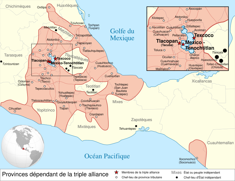
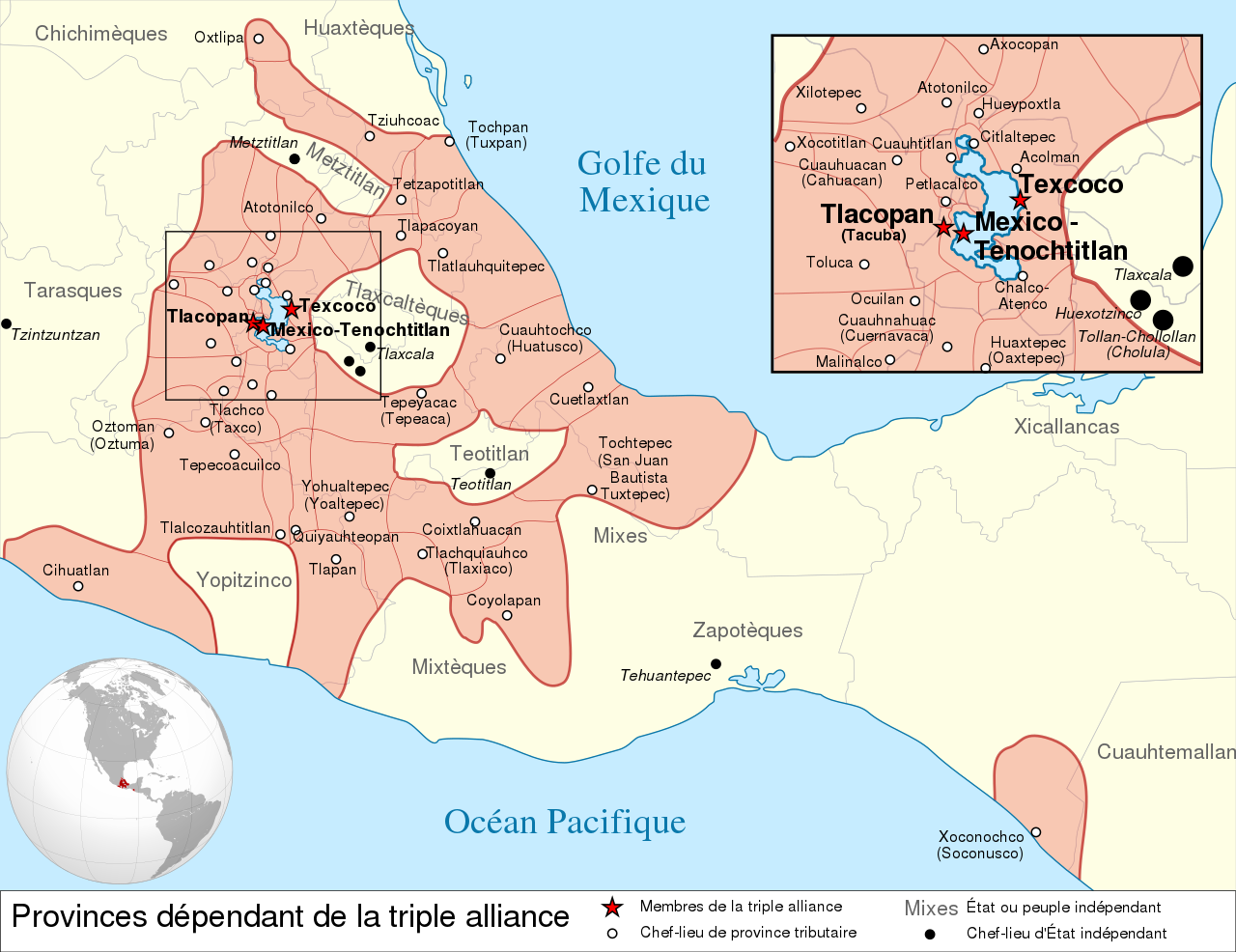
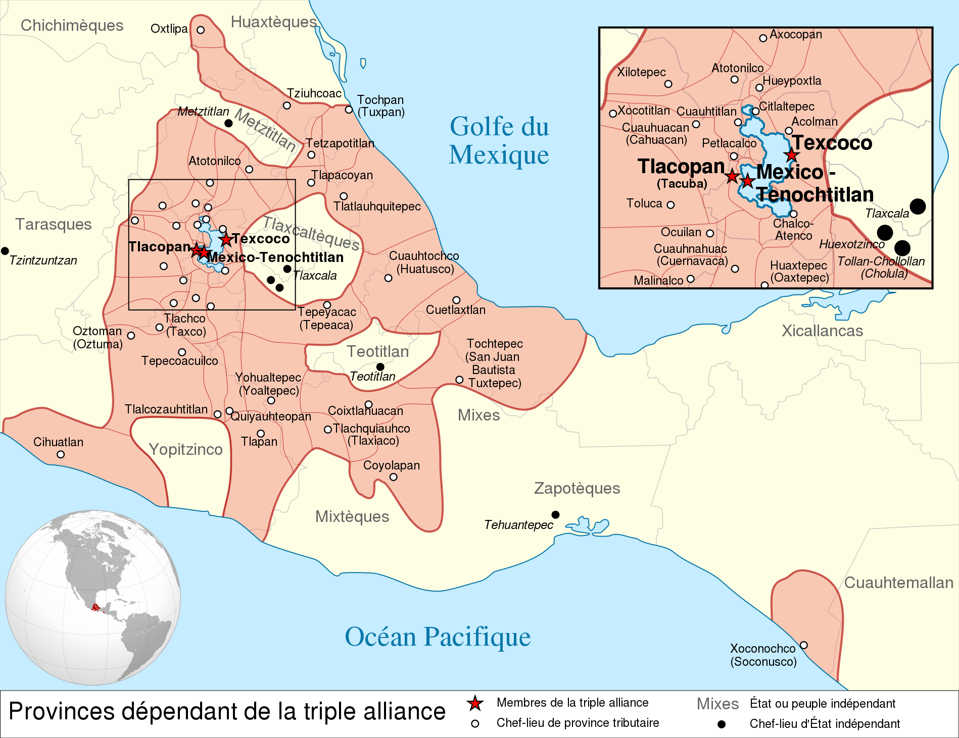
Español: Provincias tributarias de la Triple Alianza encabezada por Tenochtitlan antes de la llegada de los españoles en 1519.
English: Map of the Aztec Empire lead by Tenochtitlan circa 1519, before the arrival of the Spanish.
Français : Étendue de l'empire Aztèque soumis à la Triple Alliance, dirigée par Tenochtitlan, à l'arrivée des Espagnols en 1519. |
| Dáta | (UTC) |
| Foinse |
|
| Údar | |
| Leaganacha eile |
[] Detailed maps
Simple maps
|


.svg)
.svg)
.svg)
| Camera location | | View this and other nearby images on: OpenStreetMap |
|---|

|
This SVG file contains embedded text that can be translated into your language, using any capable SVG editor, text editor or the SVG Translate tool. For more information see: About translating SVG files. |
This W3C-unspecified vector image was created with Inkscape .
Ceadúnú
This file is licensed under the Creative Commons Attribution-Share Alike 3.0 Unported license.
- Is féidir:
- an saothar seo a roinnt – an saothar seo a chóipeáil, a dháil amach, agus a tharchur
- an saothar seo a athmheascadh – an saothar seo a oiriúnú
- Ach amháin má leantar na coinníollacha seo a leanas:
- sannadh – Ní mor creidiúint a thabhairt leis an saothar, faoi mar a shonraigh an údar nó tabharthóir an ceadúnais (ach ná húsáid modh a thugann le fios go thacaíonn sé/sí tú féin nó an úsáid a bhaineann tú as an saothar).
- comhroinn araon – Má athraíonn tú nó síneann tú amach an saothar seo, ní féidir é a dháileadh ach amhaín faoin gceadúnas céanna nó ceann cosúil leis an gceann seo.
Original upload log
This image is a derivative work of the following images:
- File:Provincias_tributarias_de_la_Triple_Alianza_(s._XVI).svg licensed with Cc-by-sa-3.0-migrated, FAL, GFDL
- 2008-12-13T03:29:16Z Yavidaxiu 949x731 (878329 Bytes) {{Information |Description={{es|1=Provincias tributarias de la Triple Alianza encabezada por Tenochtitlan antes de la llegada de los españoles. Fuente: ''Atlas del México prehispánico'', edición especial de ''Arqueología
- File:Aztec_Empire_(orthographic_projection).svg licensed with Cc-by-sa-3.0, GFDL
- 2010-02-11T12:23:41Z Sémhur 550x550 (104628 Bytes) Update with data from a sourced map.
- 2010-01-10T20:34:52Z Keepscases 550x550 (284361 Bytes) {{Information |Description={{en|1=Aztec Empire (orthographic projection)}} |Source={{own}} |Author=[[User:Keepscases|Keepscases]] |Date= |Permission= |other_versions= }} [[Category:SVG - Orthographic projections]]
Uploaded with derivativeFX
Stair chomhaid
Cliceáil ar dáta/am chun an comhad a radharc mar a bhí sé ag an am sin.
| Dáta/Am | Mionsamhail | Toisí | Úsáideoir | Nóta tráchta | |
|---|---|---|---|---|---|
| faoi láthair | 15:01, 23 Márta 2010 | | 1,898 × 1,462 (303 KB) | El Comandante | État tarasque->Tarasques + Royaumes mixtèques->Mixtèques + Correction du positionnement de 2 textes |
| 17:58, 7 Márta 2010 |  | 1,898 × 1,462 (303 KB) | El Comandante | More readable fonts | |
| 18:06, 25 Feabhra 2010 |  | 1,898 × 1,462 (306 KB) | Sémhur | Font : Nimbus Sans L | |
| 17:29, 24 Feabhra 2010 |  | 949 × 731 (305 KB) | Sémhur | 2 - Encart de la région centrale | |
| 12:55, 11 Feabhra 2010 |  | 949 × 731 (262 KB) | Sémhur | == {{int:filedesc}} == {{Information |Description={{es|1=Provincias tributarias de la Triple Alianza encabezada por Tenochtitlan antes de la llegada de los españoles en 1519.}} {{en|1=Map of the [[:en:Aztec Empire[Aztec Empire]] lead by Tenochtitlan circ |
Úsáid comhaid
Níl nasc ó aon leathanach eile don íomhá seo.
Global file usage
The following other wikis use this file:
- Úsáid ar af.wikipedia.org
- Úsáid ar ar.wikipedia.org
- Úsáid ar azb.wikipedia.org
- Úsáid ar br.wikipedia.org
- Úsáid ar el.wikipedia.org
- Úsáid ar en.wikipedia.org
- Aztecs
- List of conflicts in North America
- Aztec Empire
- Wikipedia:WikiProject Aztec/Backup 2006-07-17
- Tlaxcala (Nahua state)
- Aztec architecture
- User:Maunus/sandbox
- Template:Aztec
- List of conflicts in Mexico
- User:Bobo.03/sandbox
- User:Tisquesusa/sandbox9
- Xihuitl Temoc
- User:SomeGuyWhoRandomlyEdits/List of conflicts in Mexico
- Talk:Aztec Empire/Archive 1
- Úsáid ar en.wikibooks.org
- Úsáid ar fi.wikipedia.org
- Úsáid ar fr.wikipedia.org
- Úsáid ar hy.wikipedia.org
- Úsáid ar id.wikipedia.org
- Úsáid ar id.wikibooks.org
- Úsáid ar it.wikipedia.org
View more global usage of this file.