
Íomhá:Ascension Island Location.jpg

Size of this preview: 782 × 600 picteilín. Other resolutions: 313 × 240 picteilín | 626 × 480 picteilín | 875 × 671 picteilín.
Taispeáin leagan ardtaifigh den íomhá (875 × 671 picteilín, méid comhaid: 255 KB, cineál MIME: image/jpeg)
| Seo comhad as An Cómhaoin Viciméid. Tá an tuairisc as an leathanach tuairisc Cómhaoin a leanas thíos.
|
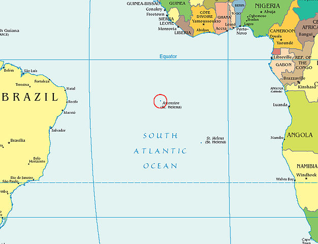
| Tuairisc |
English: A detailed location map of Ascension Island, cropped from a larger map, courtesy of the CIA World Factbook |
|||
| Foinse | Source: https://www.cia.gov/cia/publications/factbook/reference_maps/pdf/political_world.pdf | |||
| Údar | ||||
| Ceadúnas (Athúsáid a bhaint as an gcomhad seo) |
|
|||
| Leaganacha eile |
|


Original upload log
The original description page was here. All following user names refer to en.wikipedia.
- 2006-12-12 14:17 Kmusser 875×671×8 (261321 bytes)
- 2006-02-28 04:27 Iyobi 875×671×8 (248403 bytes) A detailed location [[map]] of [[Ascension Island]], cropped from a larger map, courtesy of the [[CIA World Factbook]]. '''Source''': http://www.cia.gov/cia/publications/factbook/reference_maps/pdf/political_world.pdf {{PD-USGov-CIA-WF}}
Stair chomhaid
Cliceáil ar dáta/am chun an comhad a radharc mar a bhí sé ag an am sin.
| Dáta/Am | Mionsamhail | Toisí | Úsáideoir | Nóta tráchta | |
|---|---|---|---|---|---|
| faoi láthair | 09:39, 8 Nollaig 2007 | | 875 × 671 (255 KB) | File Upload Bot (Magnus Manske) | {{BotMoveToCommons|en.wikipedia}} {{Information |Description={{en|A detailed location map of en:Ascension Island, cropped from a larger map, courtesy of the en:CIA World Factbook.<BR> '''Source''': https://www.cia.gov/cia/publications/factbook/ |
Úsáid comhaid
Tá nasc chuig an gcomhad seo ar na leathanaigh seo a leanas:
Global file usage
The following other wikis use this file:
- Úsáid ar ar.wikipedia.org
- Úsáid ar arz.wikipedia.org
- Úsáid ar ast.wikipedia.org
- Úsáid ar az.wiktionary.org
- Úsáid ar ba.wikipedia.org
- Úsáid ar be-tarask.wikipedia.org
- Úsáid ar br.wikipedia.org
- Úsáid ar bs.wikipedia.org
- Úsáid ar ca.wikipedia.org
- Úsáid ar ceb.wikipedia.org
- Úsáid ar de.wikipedia.org
- Úsáid ar de.wikivoyage.org
- Úsáid ar en.wikipedia.org
- Úsáid ar es.wikipedia.org
- Úsáid ar es.wikibooks.org
- Úsáid ar fi.wiktionary.org
- Úsáid ar gd.wikipedia.org
- Úsáid ar gl.wikipedia.org
- Úsáid ar he.wikipedia.org
- Úsáid ar hi.wikipedia.org
- Úsáid ar hi.wiktionary.org
- Úsáid ar hu.wikipedia.org
- Úsáid ar hy.wikipedia.org
- Úsáid ar id.wikipedia.org
- Úsáid ar it.wikipedia.org
- Úsáid ar it.wikivoyage.org
- Úsáid ar ka.wikipedia.org
- Úsáid ar lij.wikipedia.org
- Úsáid ar ml.wikipedia.org
- Úsáid ar mr.wikipedia.org
- Úsáid ar nl.wikipedia.org
- Úsáid ar nn.wikipedia.org
- Úsáid ar os.wikipedia.org
- Úsáid ar pl.wiktionary.org
- Úsáid ar pt.wikipedia.org
- Úsáid ar ro.wikipedia.org
- Úsáid ar ru.wikipedia.org
- Úsáid ar simple.wikipedia.org
- Úsáid ar sk.wikipedia.org
- Úsáid ar sr.wikipedia.org
- Úsáid ar tl.wikipedia.org
- Úsáid ar tr.wikipedia.org
- Úsáid ar uk.wikipedia.org
- Úsáid ar www.wikidata.org