
Íomhá:2016-Brussels-Bombings-OpenStreetMap.png

Size of this preview: 800 × 521 picteilín. Other resolutions: 320 × 208 picteilín | 640 × 417 picteilín | 1,024 × 667 picteilín | 1,280 × 834 picteilín | 2,560 × 1,668 picteilín | 4,924 × 3,208 picteilín.
Taispeáin leagan ardtaifigh den íomhá (4,924 × 3,208 picteilín, méid comhaid: 19.66 MB, cineál MIME: image/png)
| Seo comhad as An Cómhaoin Viciméid. Tá an tuairisc as an leathanach tuairisc Cómhaoin a leanas thíos.
|
| Tuairisc |
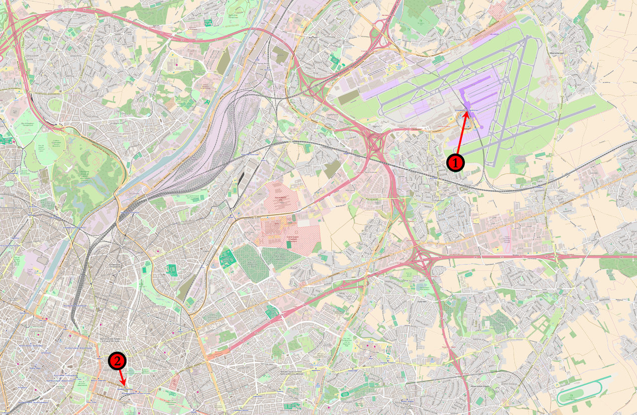
English: Map of the March 2016 Brussels bombings in relation to each other. (1) 08:00 : Concourse B of Brussels Airport. (2) 09:15 : Brussels Maelbeek metro station |
|||
| Dáta | ||||
| Foinse | Base map from OpenStreetMap | |||
| Údar | Veggies | |||
| Ceadúnas (Athúsáid a bhaint as an gcomhad seo) |
This file is licensed under the Creative Commons Attribution-Share Alike 2.0 Generic license.
|
Stair chomhaid
Cliceáil ar dáta/am chun an comhad a radharc mar a bhí sé ag an am sin.
| Dáta/Am | Mionsamhail | Toisí | Úsáideoir | Nóta tráchta | |
|---|---|---|---|---|---|
| faoi láthair | 23:05, 22 Márta 2016 | | 4,924 × 3,208 (19.66 MB) | Veggies | {{Information |Description ={{en|1=Map of the March 2016 Brussels bombings in relation to each other.<br /> '''(1)''' 08:00 : Concourse B of Brussels Airport.<br />'''(2)''' 09:15 : ''Brussels Maelbeek metro station''}} |Source =Base map fro... |
Úsáid comhaid
Tá nasc chuig an gcomhad seo ar na leathanaigh seo a leanas:
Global file usage
The following other wikis use this file:
- Úsáid ar ar.wikipedia.org
- Úsáid ar az.wikipedia.org
- Úsáid ar ca.wikipedia.org
- Úsáid ar da.wikipedia.org
- Úsáid ar en.wikipedia.org
- Úsáid ar et.wikipedia.org
- Úsáid ar fo.wikipedia.org
- Úsáid ar hi.wikipedia.org
- Úsáid ar hu.wikipedia.org
- Úsáid ar lt.wikipedia.org
- Úsáid ar lv.wikipedia.org
- Úsáid ar no.wikipedia.org
- Úsáid ar pl.wikipedia.org
- Úsáid ar pt.wikipedia.org
- Úsáid ar sco.wikipedia.org
- Úsáid ar simple.wikipedia.org
- Úsáid ar ta.wikipedia.org
- Úsáid ar tr.wikipedia.org
- Úsáid ar vi.wikipedia.org
- Úsáid ar www.wikidata.org
- Úsáid ar zh.wikipedia.org