
Íomhá:2004 indian ocean earthquake details.png
2004_indian_ocean_earthquake_details.png (413 × 408 picteilín, méid comhaid: 26 KB, cineál MIME: image/png)
| Seo comhad as An Cómhaoin Viciméid. Tá an tuairisc as an leathanach tuairisc Cómhaoin a leanas thíos.
|
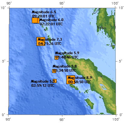
The 2004 Indian Ocean earthquake. There are 7 earthquakes on this map as of 17:00 UTC, December 26, 2004.
The original image was generated by the USGS and was found at https://earthquake.usgs.gov/recenteqsww/Maps/10/95_5.html -- Toytoy 17:40, Dec 26, 2004 (UTC).
The original image:
This image is in the public domain in the United States because it only contains materials that originally came from the United States Geological Survey, an agency of the United States Department of the Interior. For more information, see the official USGS copyright policy.
|
en:User:Toytoy's modification:
- Is féidir:
- an saothar seo a roinnt – an saothar seo a chóipeáil, a dháil amach, agus a tharchur
- an saothar seo a athmheascadh – an saothar seo a oiriúnú
- Ach amháin má leantar na coinníollacha seo a leanas:
- sannadh – Ní mor creidiúint a thabhairt leis an saothar, faoi mar a shonraigh an údar nó tabharthóir an ceadúnais (ach ná húsáid modh a thugann le fios go thacaíonn sé/sí tú féin nó an úsáid a bhaineann tú as an saothar).
- comhroinn araon – If you alter, transform, or build upon this work, you must distribute the resulting work under the same license as the original.
Note: many of the magnitudes and times of the earthquakes shown here have been revised since:
- 8.9 -> 9.0 (00:58:53) [1] archive copy at the Wayback Machine [2] archive copy at the Wayback Machine
- 7.3 -> 7.1 (04:21:29) [3] archive copy at the Wayback Machine
- 6.5 -> 6.6 (09:20:00) [4]
- 6.0 -> 5.8 [5] archive copy at the Wayback Machine
- 5.9 (02:59:12) -> 5.7 (02:59:14) [6] archive copy at the Wayback Machine
- 5.9 (01:48:46) -> 5.8 (01:48:49) [7] archive copy at the Wayback Machine
- 5.8 -> 5.7 (02:34:52) [8] archive copy at the Wayback Machine
Also, many more aftershocks have occurred. Therefore this image is out of date.
Original upload log
| Dáta/Am | Toisí | Úsáideoir | Nóta tráchta |
|---|---|---|---|
| 31 Nollaig 2004, 02:45:36 | 413 × 408 (31787 bytes) | Amgine (plé · dréachtaí) | The '''[[2004 Indian Ocean earthquake]]'''.There are 7 earthquakes on this map as of 17:00 UTC, December 26, 2004. |
Stair chomhaid
Cliceáil ar dáta/am chun an comhad a radharc mar a bhí sé ag an am sin.
| Dáta/Am | Mionsamhail | Toisí | Úsáideoir | Nóta tráchta | |
|---|---|---|---|---|---|
| faoi láthair | 09:31, 21 Iúil 2014 | | 413 × 408 (26 KB) | GifTagger | Bot: Converting file to superior PNG file. (Source: 2004_indian_ocean_earthquake_details.gif). This GIF was problematic due to non-greyscale color table. |
Úsáid comhaid
Tá nasc chuig an gcomhad seo ar na leathanaigh seo a leanas:
Global file usage
The following other wikis use this file:
- Úsáid ar de.wikipedia.org
- Úsáid ar en.wikipedia.org
- Úsáid ar id.wikipedia.org
- Úsáid ar ms.wikipedia.org
- Úsáid ar nl.wikipedia.org
- Úsáid ar no.wikipedia.org
- Úsáid ar pl.wikipedia.org
- Úsáid ar zh.wikipedia.org