
Íomhá:Asia 1200ad.jpg

Size of this preview: 800 × 494 picteilín. Other resolutions: 320 × 198 picteilín | 640 × 395 picteilín | 1,024 × 632 picteilín | 1,280 × 790 picteilín | 1,968 × 1,215 picteilín.
Taispeáin leagan ardtaifigh den íomhá (1,968 × 1,215 picteilín, méid comhaid: 731 KB, cineál MIME: image/jpeg)
| Seo comhad as An Cómhaoin Viciméid. Tá an tuairisc as an leathanach tuairisc Cómhaoin a leanas thíos.
|
Achoimriú

|
This historical map image could be re-created using vector graphics as an SVG file. This has several advantages; see Commons:Media for cleanup for more information. If an SVG form of this image is available, please upload it and afterwards replace this template with
{{vector version available|new image name}}.
It is recommended to name the SVG file “Asia 1200ad.svg”—then the template Vector version available (or Vva) does not need the new image name parameter. |


| Tuairisc |
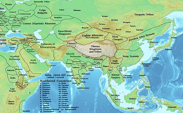
English: This image is a zoomed-in version of Eastern Hemisphere in 1200 AD updated 2008 (not correct).
Author: Thomas A. Lessman. Source URL: http://www.ThomasLessman.com/History/images/East-Hem_1200ad.jpg. Image was created by me (Thomas Lessman) based on map of Eastern Hemisphere in 1200AD. Image is free for public and/or educational use. I would appreciate a mention if this image is used elsewhere. If anyone is interested in helping further this work, please contact Thomas Lessman at talessman@yis.us. |
| Dáta | 3 Nollaig 2007 (original upload date) |
| Foinse | Transferred from en.wikipedia to Commons by Undead_warrior. |
| Údar | Talessman ar an Vicipéid Béarla |
Ceadúnú
Is mise Talessman ar an Vicipéid Béarla, sealbhóir cóipchirt an shaothair seo, agus foilsím é faoi na ceadúnais seo a leanas:

|
Tugtar cead an doiciméad seo a chóipeáil, a dháileadh agus/nó a mhodhnú faoi théarmaí an Ceadúnas Doiciméadúcháin Saor ó GNU, Leagan 1.2 nó aon leagan níos déanaí a d’fhoilsigh an Fondúireacht Bogearraí Saor in Aisce; gan aon Rannóga Inmheánacha, gan aon Téacsanna Clúdaigh Tosaigh, agus gan aon Téacsanna Clúdaigh Cúil. Tá cóip den cheadúnas san áireamh sa chuid dar teideal Ceadúnas Doiciméadúcháin Saor ó GNU. |
This file is licensed under the Creative Commons Attribution 3.0 Unported license.
Creidiúint: Talessman ar an Vicipéid Béarla
- Is féidir:
- an saothar seo a roinnt – an saothar seo a chóipeáil, a dháil amach, agus a tharchur
- an saothar seo a athmheascadh – an saothar seo a oiriúnú
- Ach amháin má leantar na coinníollacha seo a leanas:
- sannadh – Ní mor creidiúint a thabhairt leis an saothar, faoi mar a shonraigh an údar nó tabharthóir an ceadúnais (ach ná húsáid modh a thugann le fios go thacaíonn sé/sí tú féin nó an úsáid a bhaineann tú as an saothar).
Is féidir leat a roghnú an ceadúnas do rogha
Original upload log
The original description page was here. All following user names refer to en.wikipedia.
- 2008-01-14 21:32 Talessman 1968×1215×8 (748875 bytes) Minor corrections based on info from DK Atlas of World History and other sources.
- 2008-01-11 21:51 Talessman 2076×1181×8 (764936 bytes) Fixed borders of central asia, India, southeast Asia, Indonesia, and Africa. Added more information.
- 2007-12-03 20:14 Talessman 2043×1308×8 (789102 bytes) This image is a zoomed-in version of [http://en.wikipedia.org/wiki/Image:East-Hem_1200ad.jpg Eastern Hemisphere in 1200 AD]. [[Image:East-Hem_1200ad.jpg|thumb|300px|left|Eastern Hemisphere in 1200 AD.]] Author: Thomas A. Lessman. Source URL: http://www.
Stair chomhaid
Cliceáil ar dáta/am chun an comhad a radharc mar a bhí sé ag an am sin.
| Dáta/Am | Mionsamhail | Toisí | Úsáideoir | Nóta tráchta | |
|---|---|---|---|---|---|
| faoi láthair | 04:32, 25 Márta 2008 | | 1,968 × 1,215 (731 KB) | Undead warrior | {{Information |Description={{en|This image is a zoomed-in version of [http://en.wikipedia.org/wiki/Image:East-Hem_1200ad.jpg Eastern Hemisphere in 1200 AD]. thumb|300px|left|Eastern Hemisphere in 1200 AD. Author: Thomas |
Úsáid comhaid
Tá nasc chuig an gcomhad seo ar na leathanaigh seo a leanas:
Global file usage
The following other wikis use this file:
- Úsáid ar an.wikipedia.org
- Úsáid ar ar.wikipedia.org
- Úsáid ar ast.wikipedia.org
- Úsáid ar ba.wikipedia.org
- Úsáid ar bn.wikipedia.org
- Úsáid ar bs.wikipedia.org
- Úsáid ar ca.wikipedia.org
- Úsáid ar ceb.wikipedia.org
- Úsáid ar de.wikipedia.org
- Úsáid ar el.wikipedia.org
- Úsáid ar en.wikipedia.org
- Úsáid ar eo.wikipedia.org
- Úsáid ar es.wikipedia.org
- Úsáid ar fa.wikipedia.org
View more global usage of this file.