
Íomhá:Island of Ireland location map Clare.svg

Size of this PNG preview of this SVG file: 481 × 599 picteilín. Other resolutions: 192 × 240 picteilín | 385 × 480 picteilín | 616 × 768 picteilín | 822 × 1,024 picteilín | 1,643 × 2,048 picteilín | 1,450 × 1,807 picteilín.
Taispeáin leagan ardtaifigh den íomhá (Comhad SVG, ainmniúil 1,450 × 1,807 picteilíni, méid comhaid: 642 KB)
| Seo comhad as An Cómhaoin Viciméid. Tá an tuairisc as an leathanach tuairisc Cómhaoin a leanas thíos.
|
| Tuairisc |
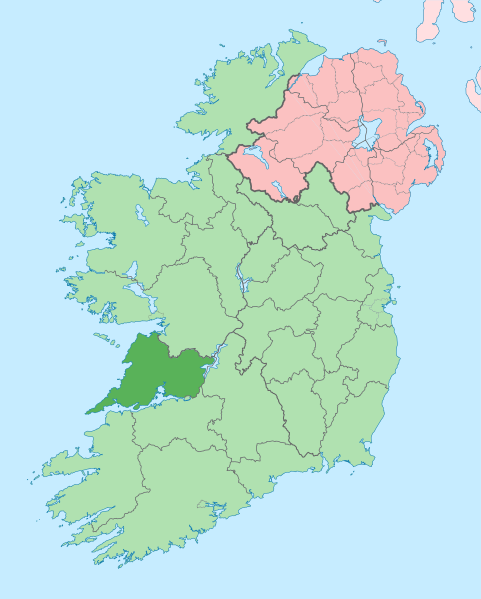
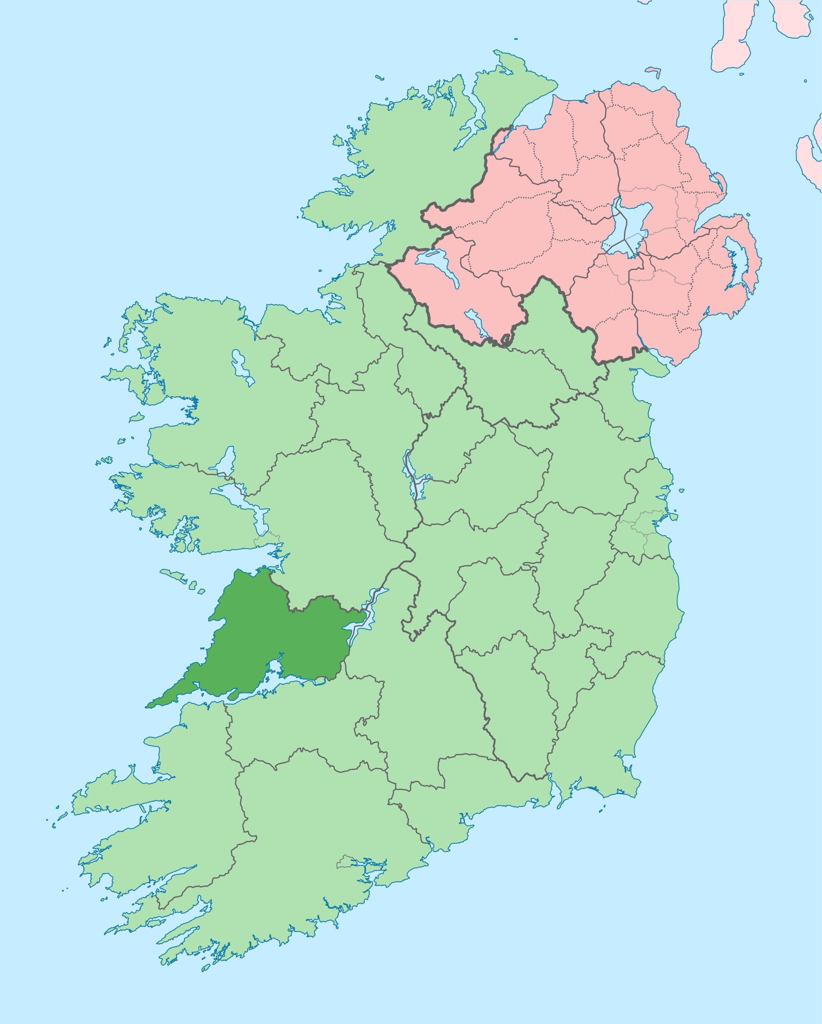
English: The island of Ireland, showing international border between Ireland and Northern Ireland, traditional provinces, traditional counties, and local authority areas in Ireland and Northern Ireland. |
| Dáta | (UTC) |
| Foinse | |
| Údar |
|
| This is a retouched picture, which means that it has been digitally altered from its original version. Modifications: Coloured in regions with county of article highlighted. The original can be viewed here: Island of Ireland location map.svg:
|
Is mise sealbhóir cóipchirt an shaothair seo agus foilsím é faoin gceadúnas seo a leanas:
This file is licensed under the Creative Commons Attribution-Share Alike 3.0 Unported license.
- Is féidir:
- an saothar seo a roinnt – an saothar seo a chóipeáil, a dháil amach, agus a tharchur
- an saothar seo a athmheascadh – an saothar seo a oiriúnú
- Ach amháin má leantar na coinníollacha seo a leanas:
- sannadh – Ní mor creidiúint a thabhairt leis an saothar, faoi mar a shonraigh an údar nó tabharthóir an ceadúnais (ach ná húsáid modh a thugann le fios go thacaíonn sé/sí tú féin nó an úsáid a bhaineann tú as an saothar).
- comhroinn araon – Má athraíonn tú nó síneann tú amach an saothar seo, ní féidir é a dháileadh ach amhaín faoin gceadúnas céanna nó ceann cosúil leis an gceann seo.
Original upload log
This image is a derivative work of the following images:
- File:Island_of_Ireland_location_map.svg licensed with Cc-by-sa-3.0
- 2010-03-06T20:43:33Z Rannpháirtí anaithnid 1450x1807 (679207 Bytes) Fix incorrectly coloured isands.
- 2010-03-03T22:19:29Z Rannpháirtí anaithnid 1450x1807 (679744 Bytes) {{Information |Description={{de|Positionskarte von [[:de:Irland|Irland]]}} Quadratische Plattkarte, N-S-Streckung 170 %. Geographische Begrenzung der Karte: * N: 55.6° N * S: 51.2° N * W: 11.0° W * O: 5.0° W {{en|Location
Uploaded with derivativeFX
Stair chomhaid
Cliceáil ar dáta/am chun an comhad a radharc mar a bhí sé ag an am sin.
| Dáta/Am | Mionsamhail | Toisí | Úsáideoir | Nóta tráchta | |
|---|---|---|---|---|---|
| faoi láthair | 14:05, 28 Meitheamh 2020 | | 1,450 × 1,807 (642 KB) | Chipmunkdavis | Colouring in Aughinish |
| 15:54, 26 Meitheamh 2020 |  | 1,450 × 1,807 (642 KB) | Chipmunkdavis | Rmv stray number in code | |
| 15:26, 26 Meitheamh 2020 |  | 1,450 × 1,807 (642 KB) | Chipmunkdavis | Merging Tipperary and Waterford shapes | |
| 12:55, 26 Meitheamh 2020 |  | 1,450 × 1,807 (643 KB) | Chipmunkdavis | Removing Limerick City | |
| 16:21, 25 Meitheamh 2020 |  | 1,450 × 1,807 (643 KB) | Chipmunkdavis | Per the Local Government Reform Act 2014, removing the Tipperary border and the Waterford City border. | |
| 16:10, 25 Meitheamh 2020 |  | 1,450 × 1,807 (646 KB) | Chipmunkdavis | Removing lots of stray objects. Fixing location of Clare and one island slightly. | |
| 15:45, 25 Meitheamh 2020 |  | 1,450 × 1,807 (695 KB) | Chipmunkdavis | Colour islands in, place all islands and borders in groups, remove some blank and redundant shapes | |
| 00:41, 19 Iúil 2010 |  | 1,450 × 1,807 (815 KB) | Mabuska | {{Information |Description={{en|The island of Ireland, showing international border between Northern Ireland and Republic of Ireland, traditional provinces, traditional counties, and local authority areas in the Republic of Ireland and Northern Ireland.}} |
Úsáid comhaid
Tá nasc chuig an gcomhad seo ar 2 an leathanach seo a leanas:
Global file usage
The following other wikis use this file:
- Úsáid ar ar.wikipedia.org
- Úsáid ar ast.wikipedia.org
- Úsáid ar bg.wikipedia.org
- Úsáid ar ca.wikipedia.org
- Úsáid ar ceb.wikipedia.org
- Úsáid ar cs.wikipedia.org
- Úsáid ar en.wikipedia.org
- County Clare
- Inagh
- Ennis
- List of Ireland-related topics
- Shannon, County Clare
- Lissycasey
- Shannon Free Zone
- Lisdoonvarna
- Cratloe
- Doolin
- Kilfenora
- Ballyvaughan
- Carran
- Kilkee
- Kilrush
- Clarecastle
- Ennistymon
- Killaloe, County Clare
- Lahinch
- Liscannor
- Mountshannon
- Newmarket-on-Fergus
- O'Brien's Bridge
- Spanish Point, County Clare
- Aughinish, County Clare
View more global usage of this file.