
Íomhá:Vancouver Island contour map.png
Size of this preview: 598 × 600 picteilín. Other resolutions: 239 × 240 picteilín | 479 × 480 picteilín | 640 × 642 picteilín.
Taispeáin leagan ardtaifigh den íomhá (640 × 642 picteilín, méid comhaid: 196 KB, cineál MIME: image/png)
| Seo comhad as An Cómhaoin Viciméid. Tá an tuairisc as an leathanach tuairisc Cómhaoin a leanas thíos.
|

|
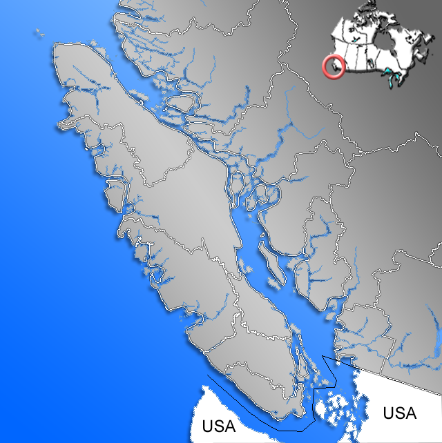
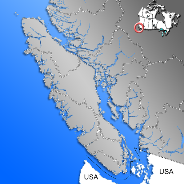
This file has been superseded by Canada Vancouver Island location map.svg. It is recommended to use the other file. Please note that deleting superseded images requires consent.
|

|
Achoimriú
| Tuairisc | Contour of Vancouver Island with Regional Districts |
| Dáta | |
| Foinse | GIS data |
| Údar | Qyd |
| Ceadúnas (Athúsáid a bhaint as an gcomhad seo) |
All |
Ceadúnú
| I, the copyright holder of this work, release this work into the public domain. This applies worldwide. In some countries this may not be legally possible; if so: I grant anyone the right to use this work for any purpose, without any conditions, unless such conditions are required by law. |

|
This map image could be re-created using vector graphics as an SVG file. This has several advantages; see Commons:Media for cleanup for more information. If an SVG form of this image is available, please upload it and afterwards replace this template with
{{vector version available|new image name}}.
It is recommended to name the SVG file “Vancouver Island contour map.svg”—then the template Vector version available (or Vva) does not need the new image name parameter. |
Stair chomhaid
Cliceáil ar dáta/am chun an comhad a radharc mar a bhí sé ag an am sin.
| Dáta/Am | Mionsamhail | Toisí | Úsáideoir | Nóta tráchta | |
|---|---|---|---|---|---|
| faoi láthair | 17:22, 12 Iúil 2006 | | 640 × 642 (196 KB) | Qyd | |
| 17:13, 12 Iúil 2006 |  | 640 × 642 (164 KB) | Qyd | {{Information |Description=Contour of Vancouver Island with Regional Districts |Source=GIS data |Date=July 2006 |Author=Qyd |Permission=All |other_versions= }} Category:City locator maps of British Columbia [[Category:Maps of British Colu |
Úsáid comhaid
Tá nasc chuig an gcomhad seo ar na leathanaigh seo a leanas:
Global file usage
The following other wikis use this file:
- Úsáid ar ar.wikipedia.org
- Úsáid ar be-tarask.wikipedia.org
- Úsáid ar el.wikipedia.org
- Úsáid ar en.wikipedia.org
- Úsáid ar es.wikipedia.org
- Úsáid ar fa.wikipedia.org
- Úsáid ar fr.wikipedia.org
- Úsáid ar gl.wikipedia.org
- Úsáid ar hak.wikipedia.org
- Úsáid ar it.wikipedia.org
- Úsáid ar ko.wikipedia.org
- Úsáid ar nn.wikipedia.org
- Úsáid ar pnb.wikipedia.org
- Úsáid ar pt.wikipedia.org
- Úsáid ar sh.wikipedia.org
- Úsáid ar sk.wikipedia.org
- Úsáid ar sl.wikipedia.org
- Úsáid ar sv.wikipedia.org
- Úsáid ar sw.wikipedia.org
- Úsáid ar tr.wikipedia.org
- Úsáid ar ug.wikipedia.org
- Úsáid ar uk.wikipedia.org
- Úsáid ar uz.wikipedia.org
- Úsáid ar vi.wikipedia.org
- Úsáid ar vo.wikipedia.org
- Úsáid ar war.wikipedia.org
- Úsáid ar zh-yue.wikipedia.org
- Úsáid ar zh.wikipedia.org