
Íomhá:Serbia and Vojvodina 1848.png
Size of this preview: 465 × 599 picteilín. Other resolutions: 186 × 240 picteilín | 372 × 480 picteilín | 717 × 924 picteilín.
Taispeáin leagan ardtaifigh den íomhá (717 × 924 picteilín, méid comhaid: 71 KB, cineál MIME: image/png)
| Seo comhad as An Cómhaoin Viciméid. Tá an tuairisc as an leathanach tuairisc Cómhaoin a leanas thíos.
|

|
This historical map image could be re-created using vector graphics as an SVG file. This has several advantages; see Commons:Media for cleanup for more information. If an SVG form of this image is available, please upload it and afterwards replace this template with
{{vector version available|new image name}}.
It is recommended to name the SVG file “Serbia and Vojvodina 1848.svg”—then the template Vector version available (or Vva) does not need the new image name parameter. |
| Tuairisc |
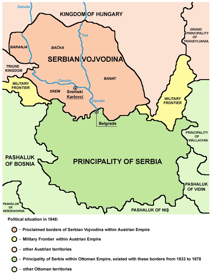
English: Principality of Serbia (autonomous principality within the Ottoman Empire) and Serbian Vojvodina (proclaimed autonomous voivodeship within the Austrian Empire) in 1848.
Српски / srpski: Kneževina Srbija (autonomna kneževina u okviru Osmanskog carstva) i Srpska Vojvodina (proklamovano autonomno vojvodstvo u okviru Austrijskog carstva) 1848. godine. |
| Dáta | (UTC) |
| Foinse | |
| Údar |
|
| This work has been released into the public domain by its author, PANONIAN. This applies worldwide. In some countries this may not be legally possible; if so: |
References
- Školski istorijski atlas, Zavod za izdavanje udžbenika Socijalističke Republike Srbije, Beograd, 1970.
- Dragomir Jankov, Vojvodina - propadanje jednog regiona, Novi Sad, 2004.
- Sima M. Ćirković, Srbi među evropskim narodima, Beograd, 2004.
- Dr Tomislav Bogavac, Nestajanje Srba, Niš, 1994.
- Milutin Perović - Milo Strugar, Istorija za 7. razred osnovne škole, Beograd - Novi Sad, 1993.
- Milutin Perović - Relja Novaković, Istorija za III razred gimnazije (opšti tip i društveno-jezički smer) i stručnih škola, Beograd, 1997.
Original upload log
This image is a derivative work of the following images:
- File:Vojvodina03.png licensed with PD-user
- 2009-07-08T19:21:05Z PANONIAN 638x737 (69422 Bytes)
- 2009-04-25T10:30:14Z PANONIAN 638x737 (75852 Bytes)
- 2008-11-01T10:11:08Z PANONIAN 638x547 (23392 Bytes)
- 2008-02-14T19:35:57Z Imbris 638x547 (18702 Bytes) Colour enhancement.
- 2007-05-01T12:14:18Z Tene 638x547 (92663 Bytes) Optimised (0)
- 2007-02-06T16:41:01Z Walden69 638x547 (129561 Bytes) Map of Vojvodina, 1848 from [[en:Image:Vojvodina03.png]] {{PD-user|PANONIAN}} [[Category:Maps of Europe]]
Uploaded with derivativeFX
Stair chomhaid
Cliceáil ar dáta/am chun an comhad a radharc mar a bhí sé ag an am sin.
| Dáta/Am | Mionsamhail | Toisí | Úsáideoir | Nóta tráchta | |
|---|---|---|---|---|---|
| faoi láthair | 16:36, 15 Eanáir 2010 | | 717 × 924 (71 KB) | PANONIAN | Reverted to version as of 16:00, 15 January 2010 - fixing thumbnail problem |
| 16:34, 15 Eanáir 2010 |  | 1,000 × 1,050 (155 KB) | PANONIAN | Reverted to version as of 14:07, 8 January 2010 - fixing thumbnail problem | |
| 16:00, 15 Eanáir 2010 |  | 717 × 924 (71 KB) | PANONIAN | improved version | |
| 14:07, 8 Eanáir 2010 |  | 1,000 × 1,050 (155 KB) | Mladifilozof | {{Information |Description=Principality of Serbia (autonomous region within the Ottoman Empire) and Serbian Vojvodina (selfproclaimed autonomous region within the [[:en:Austri |
Úsáid comhaid
Tá nasc chuig an gcomhad seo ar na leathanaigh seo a leanas:
Global file usage
The following other wikis use this file:
- Úsáid ar cy.wikipedia.org
- Úsáid ar el.wikipedia.org
- Úsáid ar en.wikipedia.org
- Úsáid ar gl.wikipedia.org
- Úsáid ar he.wikipedia.org
- Úsáid ar hr.wikipedia.org
- Úsáid ar hu.wikipedia.org
- Úsáid ar hy.wikipedia.org
- Úsáid ar it.wikipedia.org
- Úsáid ar ja.wikipedia.org
- Úsáid ar lt.wikipedia.org
- Úsáid ar mk.wikipedia.org
- Úsáid ar pt.wikipedia.org
- Úsáid ar ru.wikipedia.org
- Úsáid ar sl.wikipedia.org
- Úsáid ar sq.wikipedia.org
- Úsáid ar sv.wikipedia.org
- Úsáid ar zh.wikipedia.org