
Íomhá:Satellite image of Noordoostpolder, Netherlands (5.78E 52.71N).png
Size of this preview: 800 × 548 picteilín. Other resolutions: 320 × 219 picteilín | 640 × 439 picteilín | 1,024 × 702 picteilín.
Taispeáin leagan ardtaifigh den íomhá (1,024 × 702 picteilín, méid comhaid: 1.39 MB, cineál MIME: image/png)
| Seo comhad as An Cómhaoin Viciméid. Tá an tuairisc as an leathanach tuairisc Cómhaoin a leanas thíos.
|
.png)
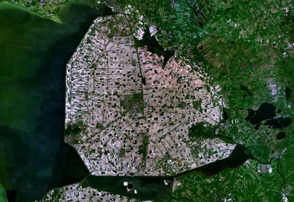
Satellite image of the Noordoostpolder, part of the Flevopolder.
Screenshot from NASA's World Wind.
| This image is in the public domain because it is a screenshot from NASA’s globe software World Wind using a public domain layer, such as Blue Marble, MODIS, Landsat, SRTM, USGS or GLOBE.
|
 |
Stair chomhaid
Cliceáil ar dáta/am chun an comhad a radharc mar a bhí sé ag an am sin.
| Dáta/Am | Mionsamhail | Toisí | Úsáideoir | Nóta tráchta | |
|---|---|---|---|---|---|
| faoi láthair | 14:30, 4 Bealtaine 2005 | | 1,024 × 702 (1.39 MB) | Galwaygirl | Satellite image of the Noordoostpolder, part of the Flevopolder. Screenshot from NASA's World Wind. {{PD}} |
Úsáid comhaid
Tá nasc chuig an gcomhad seo ar na leathanaigh seo a leanas:
Global file usage
The following other wikis use this file:
- Úsáid ar an.wikipedia.org
- Úsáid ar ar.wikipedia.org
- Úsáid ar ast.wikipedia.org
- Úsáid ar az.wikipedia.org
- Úsáid ar be.wikipedia.org
- Úsáid ar bg.wikipedia.org
- Úsáid ar br.wikipedia.org
- Úsáid ar bs.wikipedia.org
- Úsáid ar ca.wikipedia.org
- Úsáid ar cs.wikipedia.org
- Úsáid ar cy.wikipedia.org
- Úsáid ar da.wikipedia.org
- Úsáid ar de.wikipedia.org
- Úsáid ar de.wikivoyage.org
- Úsáid ar en.wikipedia.org
- Úsáid ar eo.wikipedia.org
- Úsáid ar es.wikipedia.org
- Úsáid ar et.wikipedia.org
- Úsáid ar eu.wikipedia.org
- Úsáid ar fa.wikipedia.org
- Úsáid ar fi.wikipedia.org
- Úsáid ar fo.wikipedia.org
- Úsáid ar fr.wikipedia.org
- Úsáid ar fy.wikipedia.org
- Úsáid ar gl.wikipedia.org
- Úsáid ar hak.wikipedia.org
- Úsáid ar he.wikipedia.org
- Úsáid ar he.wikivoyage.org
- Úsáid ar hr.wikipedia.org
- Úsáid ar hu.wikipedia.org
- Úsáid ar id.wikipedia.org
- Úsáid ar it.wikipedia.org
- Úsáid ar kk.wikipedia.org
- Úsáid ar ko.wikipedia.org
- Úsáid ar lt.wikipedia.org
View more global usage of this file.
.png)
.png)