
Íomhá:River Nith estuary.jpg

Size of this preview: 800 × 533 picteilín. Other resolutions: 320 × 213 picteilín | 640 × 427 picteilín | 1,024 × 683 picteilín | 1,280 × 853 picteilín | 2,560 × 1,707 picteilín | 3,504 × 2,336 picteilín.
Taispeáin leagan ardtaifigh den íomhá (3,504 × 2,336 picteilín, méid comhaid: 8.68 MB, cineál MIME: image/jpeg)
| Seo comhad as An Cómhaoin Viciméid. Tá an tuairisc as an leathanach tuairisc Cómhaoin a leanas thíos.
|
Achoimriú
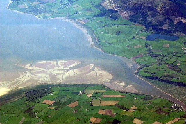
| Tuairisc | The estuary of the River Nith, Scotland, at low tide; opening into Solway Firth. This is a view of the Nith estuary from the north-east. The group of buildings at bottom right is the village of Glencaple. At bottom left near the wooded area is Caerlaverock Castle. At top right is Loch Kindar and the hill above is called Criffel. Just beyond the top left of photo is the birthplace of John Paul Jones. |
| Dáta | |
| Foinse | https://www.flickr.com/photos/52614599@N00/483602946 |
| Údar | Doc Searls from Santa Barbara, USA |
Ceadúnú
This file is licensed under the Creative Commons Attribution-Share Alike 2.0 Generic license.
- Is féidir:
- an saothar seo a roinnt – an saothar seo a chóipeáil, a dháil amach, agus a tharchur
- an saothar seo a athmheascadh – an saothar seo a oiriúnú
- Ach amháin má leantar na coinníollacha seo a leanas:
- sannadh – Ní mor creidiúint a thabhairt leis an saothar, faoi mar a shonraigh an údar nó tabharthóir an ceadúnais (ach ná húsáid modh a thugann le fios go thacaíonn sé/sí tú féin nó an úsáid a bhaineann tú as an saothar).
- comhroinn araon – Má athraíonn tú nó síneann tú amach an saothar seo, ní féidir é a dháileadh ach amhaín faoin gceadúnas céanna nó ceann cosúil leis an gceann seo.
| This image was originally posted to Flickr by dsearls at https://www.flickr.com/photos/52614599@N00/483602946. It was reviewed on 5 Bealtaine 2007 by FlickreviewR and was confirmed to be licensed under the terms of the cc-by-sa-2.0. |
This is a view of the Nith estuary from the north-east. The group of buildings at bottom right is the village of Glencaple. At bottom left near the wooded area is Caerlaverock Castle. At top right is Loch Kindar and the hill above is called Criffel. Just beyond the top left of photo is the birthplace of John Paul Jones.
Stair chomhaid
Cliceáil ar dáta/am chun an comhad a radharc mar a bhí sé ag an am sin.
| Dáta/Am | Mionsamhail | Toisí | Úsáideoir | Nóta tráchta | |
|---|---|---|---|---|---|
| faoi láthair | 07:14, 5 Bealtaine 2007 | | 3,504 × 2,336 (8.68 MB) | Sandstein | {{Information |Description= The estuary of the River Nith, Scotland, at low tide; opening into Solway Firth. On the near shore, Bowness-on-Solway. On the far, Annan, in Dumfries and Galloway. |Source= http://www.flickr.com/photos/52614599@N00/483602946 |D |
Úsáid comhaid
Tá nasc chuig an gcomhad seo ar na leathanaigh seo a leanas:
Global file usage
The following other wikis use this file:
- Úsáid ar ar.wikipedia.org
- Úsáid ar arz.wikipedia.org
- Úsáid ar ast.wikipedia.org
- Úsáid ar bn.wikipedia.org
- Úsáid ar br.wikipedia.org
- Úsáid ar ceb.wikipedia.org
- Úsáid ar cs.wikipedia.org
- Úsáid ar cy.wikipedia.org
- Úsáid ar dag.wikipedia.org
- Úsáid ar de.wikipedia.org
- Úsáid ar en.wikipedia.org
- Úsáid ar en.wikivoyage.org
- Úsáid ar eo.wikipedia.org
- Úsáid ar es.wikipedia.org
- Úsáid ar eu.wikipedia.org
- Úsáid ar fa.wikipedia.org
- Úsáid ar fr.wikipedia.org
- Úsáid ar fy.wikipedia.org
- Úsáid ar gd.wikipedia.org
- Úsáid ar gv.wikipedia.org
- Úsáid ar hak.wikipedia.org
- Úsáid ar id.wikipedia.org
- Úsáid ar incubator.wikimedia.org
- Úsáid ar it.wikipedia.org
- Úsáid ar it.wikibooks.org
- Úsáid ar it.wikiversity.org
- Úsáid ar ja.wikipedia.org
- Úsáid ar kbd.wikipedia.org
- Úsáid ar lt.wikipedia.org
- Úsáid ar nl.wikipedia.org
View more global usage of this file.