
Íomhá:Pechora.jpg

Size of this preview: 463 × 599 picteilín. Other resolutions: 185 × 240 picteilín | 371 × 480 picteilín | 593 × 768 picteilín | 791 × 1,024 picteilín | 1,700 × 2,200 picteilín.
Taispeáin leagan ardtaifigh den íomhá (1,700 × 2,200 picteilín, méid comhaid: 803 KB, cineál MIME: image/jpeg)
| Seo comhad as An Cómhaoin Viciméid. Tá an tuairisc as an leathanach tuairisc Cómhaoin a leanas thíos.
|
Achoimriú
| Tuairisc |
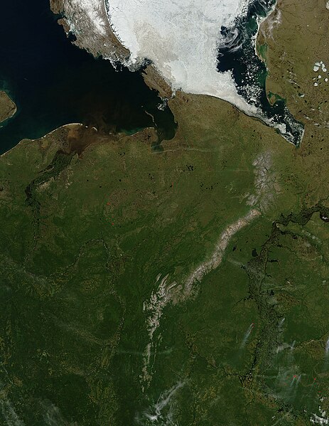
English: Pechora River
sattelite photo On July 3, 2004, sea ice still covered much of the Kara Sea in Northeastern Russia, near the western edge of Siberia, when the Moderate Resolution Imaging Spectroradiometer (MODIS) on NASA’s Aqua satellite captured this image. The southern tip of Novaya Zemlya Island curves out of the upper left corner of the image and is separated from Vaygach Island by Karskiye Vorota Strait. The narrow Yugorskiy Shar Strait, which separates Vaygach Island from mainland Russia, is clogged with sea ice. To the west, image left, the Pechora River is emptying brown, sediment-rich water into the Pechorskoye Sea. The water is probably loaded with mud as the far north thaws for the summer. In the lower right corner of the image, MODIS has detected a handful of fires, marked in red, which are sending light plumes of smoke to the southwest. |
| Foinse | Obair féin |
| Údar | user:Svart |
Ceadúnú
| Chruthaigh NASA an comhad seo, agus tógadh as suíomh Greasáin NASA nó foilseachán NASA é. Tá gach saothar den saghas sin sa fearann poiblí ach amháin an suaitheantas NASA, mar ní féidir saothair de chuid rialtas cónaidhme Stáit Aontaithe Mheiriceá a chur faoi chóipcheart. Féach ar an leathanach pholasaí cóipchirt NASA nó an leathanach pholasaí íomhanna JPL le tuilleadh eolais. | ||
 |
Rabhaidh:
|
Stair chomhaid
Cliceáil ar dáta/am chun an comhad a radharc mar a bhí sé ag an am sin.
| Dáta/Am | Mionsamhail | Toisí | Úsáideoir | Nóta tráchta | |
|---|---|---|---|---|---|
| faoi láthair | 21:47, 27 Márta 2006 | | 1,700 × 2,200 (803 KB) | Svart~commonswiki | '''Pechora River''' sattelite photo On July 3, 2004, sea ice still covered much of the Kara Sea in Northeastern Russia, near the western edge of Siberia, when the Moderate Resolution Imaging Spectroradiometer (MODIS) on NASA’s Aqua satellite captured |
Úsáid comhaid
Tá nasc chuig an gcomhad seo ar na leathanaigh seo a leanas:
Global file usage
The following other wikis use this file:
- Úsáid ar af.wikipedia.org
- Úsáid ar ar.wikipedia.org
- Úsáid ar arz.wikipedia.org
- Úsáid ar ast.wikipedia.org
- Úsáid ar az.wikipedia.org
- Úsáid ar be.wikipedia.org
- Úsáid ar bg.wikipedia.org
- Úsáid ar bn.wikipedia.org
- Úsáid ar ca.wikipedia.org
- Úsáid ar ceb.wikipedia.org
- Úsáid ar ce.wikipedia.org
- Úsáid ar de.wikivoyage.org
- Úsáid ar diq.wikipedia.org
- Úsáid ar en.wikipedia.org
- Úsáid ar eo.wikipedia.org
- Úsáid ar es.wikipedia.org
- Úsáid ar eu.wikipedia.org
- Úsáid ar fi.wikipedia.org
- Úsáid ar fr.wikivoyage.org
- Úsáid ar gl.wikipedia.org
- Úsáid ar he.wikipedia.org
- Úsáid ar hy.wikipedia.org
- Úsáid ar id.wikipedia.org
- Úsáid ar lmo.wikipedia.org
- Úsáid ar lv.wikipedia.org
- Úsáid ar mhr.wikipedia.org
- Úsáid ar mrj.wikipedia.org
- Úsáid ar myv.wikipedia.org
- Úsáid ar mzn.wikipedia.org
View more global usage of this file.