
Íomhá:North Sea map-en.png

Size of this preview: 479 × 600 picteilín. Other resolutions: 192 × 240 picteilín | 383 × 480 picteilín | 613 × 768 picteilín | 817 × 1,024 picteilín | 2,475 × 3,100 picteilín.
Taispeáin leagan ardtaifigh den íomhá (2,475 × 3,100 picteilín, méid comhaid: 3.8 MB, cineál MIME: image/png)
| Seo comhad as An Cómhaoin Viciméid. Tá an tuairisc as an leathanach tuairisc Cómhaoin a leanas thíos.
|
P
Achoimriú
| Tuairisc | |
| Dáta | |
| Foinse |
Obair féin using en:GRASS GIS, en:Inkscape and en:GIMP. Data sources:
Map Projection: Universal Transverse Mercator Typeface: Gentium Book Basic from SIL International |
| Údar | Halava |
| Leaganacha eile |
  |
Ceadúnú
Is mise sealbhóir cóipchirt an shaothair seo agus foilsím é faoi na ceadúnais seo a leanas:
This file is licensed under the Creative Commons Attribution-Share Alike 3.0 Unported license.
- Is féidir:
- an saothar seo a roinnt – an saothar seo a chóipeáil, a dháil amach, agus a tharchur
- an saothar seo a athmheascadh – an saothar seo a oiriúnú
- Ach amháin má leantar na coinníollacha seo a leanas:
- sannadh – Ní mor creidiúint a thabhairt leis an saothar, faoi mar a shonraigh an údar nó tabharthóir an ceadúnais (ach ná húsáid modh a thugann le fios go thacaíonn sé/sí tú féin nó an úsáid a bhaineann tú as an saothar).
- comhroinn araon – Má athraíonn tú nó síneann tú amach an saothar seo, ní féidir é a dháileadh ach amhaín faoin gceadúnas céanna nó ceann cosúil leis an gceann seo.

|
Tugtar cead an doiciméad seo a chóipeáil, a dháileadh agus/nó a mhodhnú faoi théarmaí an Ceadúnas Doiciméadúcháin Saor ó GNU, Leagan 1.2 nó aon leagan níos déanaí a d’fhoilsigh an Fondúireacht Bogearraí Saor in Aisce; gan aon Rannóga Inmheánacha, gan aon Téacsanna Clúdaigh Tosaigh, agus gan aon Téacsanna Clúdaigh Cúil. Tá cóip den cheadúnas san áireamh sa chuid dar teideal Ceadúnas Doiciméadúcháin Saor ó GNU. |
Is féidir leat a roghnú an ceadúnas do rogha
| Annotations | This image is annotated: View the annotations at Commons |
Stair chomhaid
Cliceáil ar dáta/am chun an comhad a radharc mar a bhí sé ag an am sin.
| Dáta/Am | Mionsamhail | Toisí | Úsáideoir | Nóta tráchta | |
|---|---|---|---|---|---|
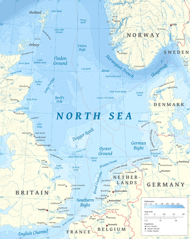
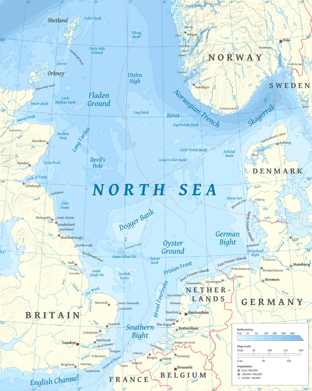
| faoi láthair | 17:23, 5 Márta 2015 | | 2,475 × 3,100 (3.8 MB) | Tandru7 | {{Information |Description=Map of the North Sea |Source=Wiki Commons |Date=3/5/15 |Author= |Permission= |other_versions= }} |
| 14:48, 15 Deireadh Fómhair 2010 |  | 2,475 × 3,100 (3.8 MB) | Halava | New place names | |
| 17:34, 12 Deireadh Fómhair 2010 |  | 2,475 × 3,100 (3.79 MB) | Halava | Some corrections; several new place names | |
| 11:02, 12 Deireadh Fómhair 2010 |  | 2,475 × 3,100 (3.78 MB) | Halava | Minor corrections; improved legibility; Horns Rev | |
| 08:09, 10 Deireadh Fómhair 2010 |  | 2,475 × 3,100 (3.72 MB) | Halava | Exclusive economic zones; Heligoland | |
| 09:26, 9 Deireadh Fómhair 2010 |  | 2,475 × 3,100 (3.64 MB) | Halava | Lindisfarne; Norfolk Banks instead of Wells Bank | |
| 20:27, 8 Deireadh Fómhair 2010 |  | 2,475 × 3,100 (3.63 MB) | Halava | Outlined Dogger Bank, fixed a typo | |
| 17:04, 8 Deireadh Fómhair 2010 |  | 2,475 × 3,100 (3.61 MB) | Halava | Several improvements | |
| 10:52, 6 Deireadh Fómhair 2010 |  | 2,475 × 3,100 (3.37 MB) | Halava | Fixed two typos, switched color model to RGB | |
| 10:09, 6 Deireadh Fómhair 2010 |  | 2,475 × 3,100 (2.57 MB) | Halava | {{Information |Description={{en|1=Map of the North Sea.}} |Source={{own}} using GRASS GIS, Inkscape and GIMP. Data sources: * Elevation and bathymetry data from NGDC ETOPO1 * Coastlines, rivers and borders from NGDC World Data Bank II * Cities from OpenS |
Úsáid comhaid
Tá nasc chuig an gcomhad seo ar na leathanaigh seo a leanas:
Global file usage
The following other wikis use this file:
- Úsáid ar af.wikipedia.org
- Úsáid ar ar.wikipedia.org
- Úsáid ar arz.wikipedia.org
- Úsáid ar ast.wikipedia.org
- Úsáid ar ba.wikipedia.org
- Úsáid ar be-tarask.wikipedia.org
- Úsáid ar bg.wikipedia.org
- Úsáid ar br.wikipedia.org
- Úsáid ar ca.wikipedia.org
- Úsáid ar cs.wikipedia.org
- Úsáid ar cy.wikipedia.org
- Úsáid ar de.wikipedia.org
- Úsáid ar de.wikivoyage.org
- Úsáid ar el.wikipedia.org
- Úsáid ar en.wikipedia.org
- North Sea
- Skagerrak
- SMS Lützow
- HMS King Edward VII
- HMS Marlborough (1912)
- HMS Emperor of India
- HMS Africa (1905)
- Horns Rev
- HMS Britannia (1904)
- Silverpit crater
- Broad Fourteens
- Dogger Bank
- Long Forties
- HMS Hibernia (1905)
- Fisher Bank
- Norwegian trench
- Silver Pit
- Wikipedia:Userboxes/Location
- Operation Wikinger
- HMS Commonwealth
- Northern Patrol
- Raid on Scarborough, Hartlepool and Whitby
- HMS Hindustan (1903)
- User:Buaidh
- Southern Bight
- History of the North Sea
- First Ostend Raid
- Bombardment of Yarmouth and Lowestoft
View more global usage of this file.