
Íomhá:LocationLiechtenstein.png
Níl aon taifeach is mó ar fáil.
LocationLiechtenstein.png (250 × 115 picteilín, méid comhaid: 6 KB, cineál MIME: image/png)
| Seo comhad as An Cómhaoin Viciméid. Tá an tuairisc as an leathanach tuairisc Cómhaoin a leanas thíos.
|
Achoimriú
| Tuairisc |
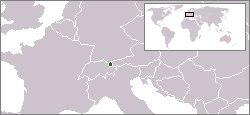
English: Location map for Liechtenstein.
Deutsch: Karte zur Lage von Liechtenstein. |
|||
| Dáta | ||||
| Foinse | Originally created for English Wikipedia by Vardion. | |||
| Údar | Vardion | |||
| Leaganacha eile |
|


Ceadúnú
| |
This work has been released into the public domain by its author, Vardion, at the Béarla an Vicipéid project. This applies worldwide. In case this is not legally possible: |
| Annotations | This image is annotated: View the annotations at Commons |
Stair chomhaid
Cliceáil ar dáta/am chun an comhad a radharc mar a bhí sé ag an am sin.
| Dáta/Am | Mionsamhail | Toisí | Úsáideoir | Nóta tráchta | |
|---|---|---|---|---|---|
| faoi láthair | 05:59, 16 Nollaig 2004 | | 250 × 115 (6 KB) | EugeneZelenko | Location map for the Liechtenstein.<br/>Originally created for English Wikipedia by Vardion.<br/>{{PD}}<br/>Category:Country locator maps |
| 15:11, 12 Nollaig 2004 |  | 250 × 115 (6 KB) | SpeedyGonsales | Location Liechtenstein |
Úsáid comhaid
Níl nasc ó aon leathanach eile don íomhá seo.
Global file usage
The following other wikis use this file:
- Úsáid ar als.wikipedia.org
- Úsáid ar arc.wikipedia.org
- Úsáid ar av.wikipedia.org
- Úsáid ar bg.wikipedia.org
- Úsáid ar bpy.wikipedia.org
- Úsáid ar br.wikipedia.org
- Úsáid ar ceb.wikipedia.org
- Úsáid ar ckb.wikipedia.org
- Úsáid ar cv.wikipedia.org
- Úsáid ar de.wikipedia.org
- Úsáid ar de.wikibooks.org
- Úsáid ar de.wikinews.org
- Úsáid ar de.wiktionary.org
- Úsáid ar dsb.wikipedia.org
- Úsáid ar el.wiktionary.org
- Úsáid ar en.wikipedia.org
- Úsáid ar en.wikivoyage.org
- Úsáid ar en.wiktionary.org
- Úsáid ar eo.wikipedia.org
- Úsáid ar eo.wiktionary.org
- Úsáid ar eu.wiktionary.org
- Úsáid ar fa.wikipedia.org
- Úsáid ar fiu-vro.wikipedia.org
- Úsáid ar fr.wikipedia.org
- Úsáid ar fr.wikinews.org
- Úsáid ar fy.wikipedia.org
- Úsáid ar gu.wikipedia.org
- Úsáid ar he.wikivoyage.org
- Úsáid ar hif.wikipedia.org
- Úsáid ar ht.wikipedia.org
- Úsáid ar ia.wikipedia.org
- Úsáid ar id.wikipedia.org
- Úsáid ar incubator.wikimedia.org
- Úsáid ar it.wikivoyage.org
- Úsáid ar ja.wikipedia.org
- Úsáid ar jv.wikipedia.org
- Úsáid ar ka.wiktionary.org
View more global usage of this file.