
Íomhá:Karte Innsbruck - Katastralgemeinden und Statistische Stadtteile.png
Size of this preview: 435 × 599 picteilín. Other resolutions: 174 × 240 picteilín | 349 × 480 picteilín | 558 × 768 picteilín | 1,188 × 1,635 picteilín.
Taispeáin leagan ardtaifigh den íomhá (1,188 × 1,635 picteilín, méid comhaid: 435 KB, cineál MIME: image/png)
| Seo comhad as An Cómhaoin Viciméid. Tá an tuairisc as an leathanach tuairisc Cómhaoin a leanas thíos.
|
Achoimriú
| Tuairisc |
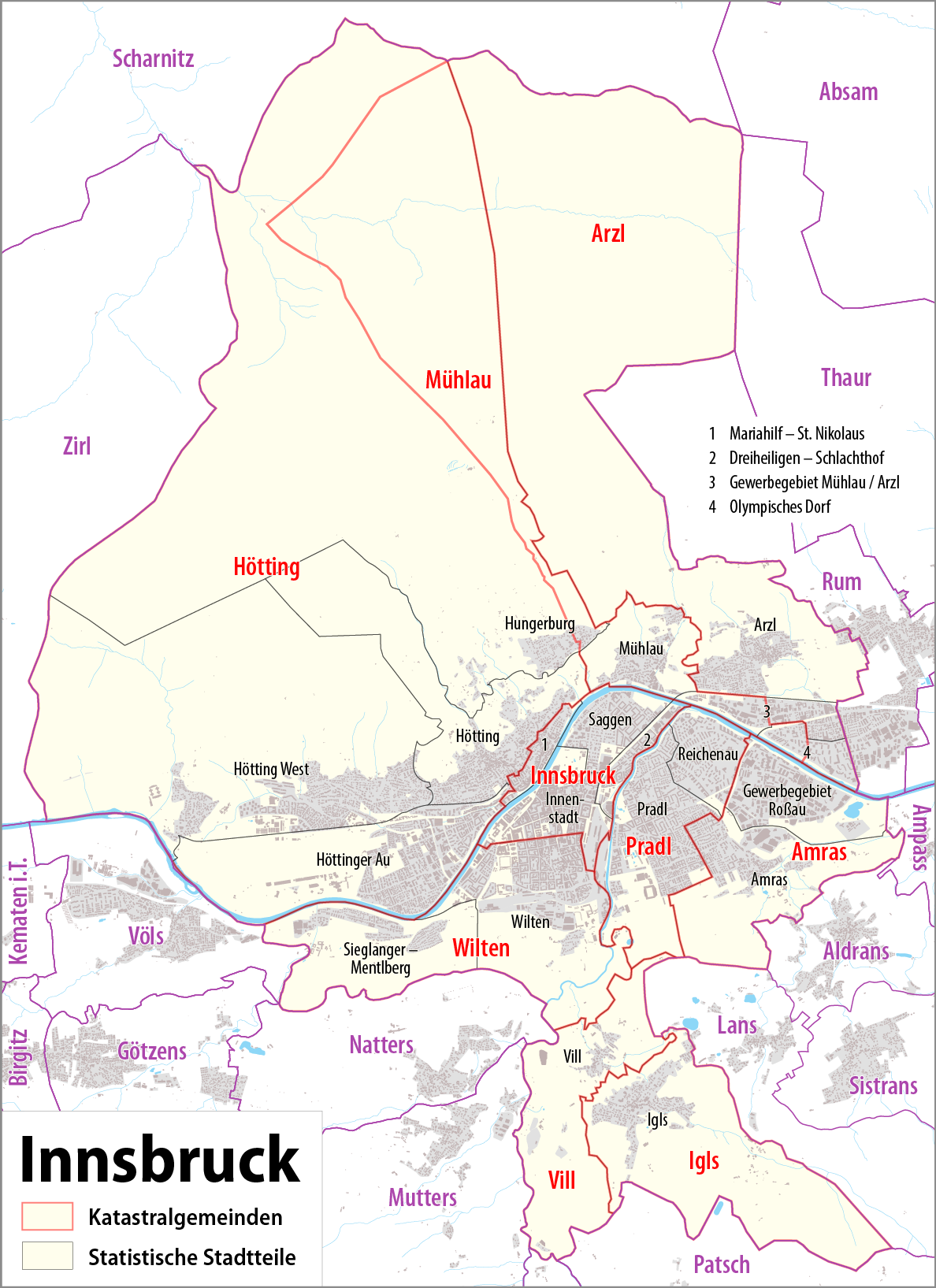
Deutsch: Karte von Innsbruck: Katastralgemeinden und statistische Stadtteile
English: Map of Innsbruck: cadastral communities and statistical districts |
|||
| Dáta | see file history | |||
| Foinse |
Obair féin, using
|
|||
| Údar | Maximilian Dörrbecker (Chumwa) | |||
| Ceadúnas (Athúsáid a bhaint as an gcomhad seo) |
This file is licensed under the Creative Commons Attribution-Share Alike 2.0 Generic license.
Sie dürfen das Bild zu den folgenden Bedingungen nutzen:
|
|||
| Leaganacha eile |
Statistical districs of Innsbruck
Cadastral communities of Innsbruck
|


Stair chomhaid
Cliceáil ar dáta/am chun an comhad a radharc mar a bhí sé ag an am sin.
| Dáta/Am | Mionsamhail | Toisí | Úsáideoir | Nóta tráchta | |
|---|---|---|---|---|---|
| faoi láthair | 22:20, 7 Meitheamh 2015 | | 1,188 × 1,635 (435 KB) | Cmdrjameson | Compressed with pngout. Reduced by 254kB (36% decrease). |
| 20:33, 3 Meán Fómhair 2014 |  | 1,188 × 1,635 (690 KB) | Chumwa | ||
| 19:11, 8 Lúnasa 2014 |  | 1,188 × 1,635 (689 KB) | Chumwa | ||
| 23:17, 7 Lúnasa 2014 |  | 1,188 × 1,635 (634 KB) | Chumwa | ||
| 22:38, 7 Lúnasa 2014 |  | 1,188 × 1,635 (633 KB) | Chumwa | == {{int:filedesc}} == {{Information |Description = {{de|1=Karte von Innsbruck: Katastralgemeinden und Statistische Stadtteile}} {{en|1=Map of Innsbruck: cadastral communities and statistic districts}} |Source={{own}}, using OpenStreetMap data f... |
Úsáid comhaid
Tá nasc chuig an gcomhad seo ar na leathanaigh seo a leanas:
Global file usage
The following other wikis use this file:
- Úsáid ar ca.wikipedia.org
- Úsáid ar de.wikipedia.org
- Úsáid ar en.wikipedia.org
- Úsáid ar et.wikipedia.org
- Úsáid ar gl.wikipedia.org
- Úsáid ar hy.wikipedia.org
- Úsáid ar incubator.wikimedia.org
- Úsáid ar lld.wikipedia.org
- Úsáid ar rm.wikipedia.org
- Úsáid ar tt.wikipedia.org
- Úsáid ar vep.wikipedia.org
- Úsáid ar vi.wikipedia.org
- Úsáid ar www.wikidata.org