
Íomhá:Extension of Germany (1935-1939)-es.svg

Size of this PNG preview of this SVG file: 659 × 600 picteilín. Other resolutions: 264 × 240 picteilín | 527 × 480 picteilín | 844 × 768 picteilín | 1,125 × 1,024 picteilín | 2,250 × 2,048 picteilín | 790 × 719 picteilín.
Taispeáin leagan ardtaifigh den íomhá (Comhad SVG, ainmniúil 790 × 719 picteilíni, méid comhaid: 648 KB)
| Seo comhad as An Cómhaoin Viciméid. Tá an tuairisc as an leathanach tuairisc Cómhaoin a leanas thíos.
|
| Tuairisc |
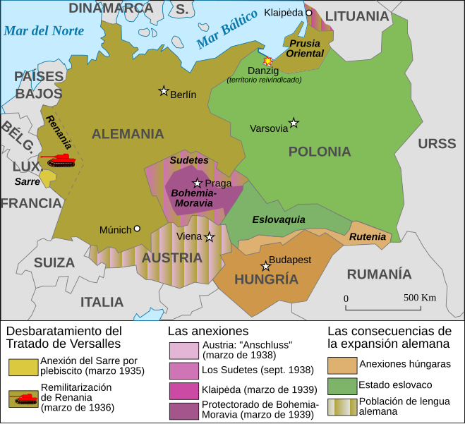
Español: Mapa de la extensión de Alemania (1935-1939) |
||||||||
| Dáta | |||||||||
| Foinse | Based on Image:Extension of Germany (1935-1939)-fr.svg | ||||||||
| Údar | JMPerez | ||||||||
| Ceadúnas (Athúsáid a bhaint as an gcomhad seo) |
Is mise sealbhóir cóipchirt an shaothair seo agus foilsím é faoi na ceadúnais seo a leanas:
This file is licensed under the Creative Commons Attribution-Share Alike 2.5 Generic, 2.0 Generic and 1.0 Generic license.
Is féidir leat a roghnú an ceadúnas do rogha |
||||||||
| Leaganacha eile |
Français : Carte en français Image:Extension of Germany (1935-1939)-fr.svg English: French version Image:Extension of Germany (1935-1939)-fr.svg |

-es.svg)
-fr.svg)
-es.svg)
|
This SVG file contains embedded text that can be translated into your language, using any capable SVG editor, text editor or the SVG Translate tool. For more information see: About translating SVG files. |
-es.svg)
Stair chomhaid
Cliceáil ar dáta/am chun an comhad a radharc mar a bhí sé ag an am sin.
| Dáta/Am | Mionsamhail | Toisí | Úsáideoir | Nóta tráchta | |
|---|---|---|---|---|---|
| faoi láthair | 20:01, 14 Feabhra 2017 | | 790 × 719 (648 KB) | Rowanwindwhistler | https://en.wikipedia.org/wiki/Wikipedia:WikiProject_Maps/Conventions Fake text added Múnich |
| 16:11, 5 Meán Fómhair 2007 |  | 741 × 674 (116 KB) | Redtony | "Prusia Oriental" traducido | |
| 16:38, 18 Lúnasa 2007 |  | 741 × 674 (116 KB) | JMPerez~commonswiki | {{Information |Description={{es}}Mapa de la extensión de Alemania (1935-1939) |Source=Based on Image:Extension of Germany (1935-1939)-fr.svg |Date=18/08/2007 |Author=JMPerez |Permission={{self2|GFDL|cc-by-sa-2.5,2.0,1.0}} |other_ver |
-fr.svg)
Úsáid comhaid
Níl nasc ó aon leathanach eile don íomhá seo.
Global file usage
The following other wikis use this file:
- Úsáid ar ast.wikipedia.org
- Úsáid ar ca.wikipedia.org
- Úsáid ar es.wikipedia.org
- Úsáid ar gl.wikipedia.org
-es.svg)