
Íomhá:CarthageMapDe.png
Níl aon taifeach is mó ar fáil.
CarthageMapDe.png (770 × 447 picteilín, méid comhaid: 106 KB, cineál MIME: image/png)
| Seo comhad as An Cómhaoin Viciméid. Tá an tuairisc as an leathanach tuairisc Cómhaoin a leanas thíos.
|
Achoimriú
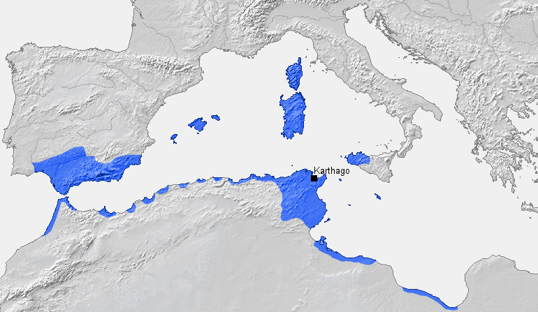
| Tuairisc |
English: Location of Carthage and Carthaginian influence sphere before the First Punic War (264 BC) |
| Foinse |
Obair féin, based on Putzger Atlas und Chronik zur Weltgeschichte, Berlin, 2002 |
| Údar | BishkekRocks (plé · dréachtaí) |
Ceadúnú
| I, the copyright holder of this work, release this work into the public domain. This applies worldwide. In some countries this may not be legally possible; if so: I grant anyone the right to use this work for any purpose, without any conditions, unless such conditions are required by law. |
Stair chomhaid
Cliceáil ar dáta/am chun an comhad a radharc mar a bhí sé ag an am sin.
| Dáta/Am | Mionsamhail | Toisí | Úsáideoir | Nóta tráchta | |
|---|---|---|---|---|---|
| faoi láthair | 15:32, 18 Márta 2006 | | 770 × 447 (106 KB) | BishkekRocks | Location of Carthage and Carthaginian influence sphere before the First Punic War (264 BC) Source: Self-made, based on Putzger Atlas und Chronik zur Weltgeschichte, Berlin, 2002 Template: [http://www.demis.nl/wms/mapclip.htm] Author: ~~~ [[Category:Ca |
Úsáid comhaid
Tá nasc chuig an gcomhad seo ar na leathanaigh seo a leanas:
Global file usage
The following other wikis use this file:
- Úsáid ar als.wikipedia.org
- Úsáid ar ar.wikipedia.org
- Úsáid ar ba.wikipedia.org
- Úsáid ar be.wikipedia.org
- Úsáid ar bg.wikipedia.org
- Úsáid ar ca.wikipedia.org
- Úsáid ar de.wikipedia.org
- Úsáid ar de.wikibooks.org
- Úsáid ar eo.wikipedia.org
- Úsáid ar es.wikipedia.org
- Úsáid ar fa.wikipedia.org
- Úsáid ar fr.wikipedia.org
- Úsáid ar fy.wikipedia.org
- Úsáid ar hu.wikipedia.org
- Úsáid ar hy.wikipedia.org
- Úsáid ar id.wikipedia.org
- Úsáid ar it.wikipedia.org
- Úsáid ar ja.wikipedia.org
- Úsáid ar ka.wikipedia.org
- Úsáid ar ku.wikipedia.org
- Úsáid ar la.wikipedia.org
- Úsáid ar lt.wikipedia.org
- Úsáid ar lv.wikipedia.org
- Úsáid ar rm.wikipedia.org
- Úsáid ar ru.wikipedia.org
- Úsáid ar sh.wikipedia.org
- Úsáid ar sk.wikipedia.org
- Úsáid ar sl.wikipedia.org
- Úsáid ar sr.wikipedia.org
- Úsáid ar sw.wikipedia.org
- Úsáid ar tt.wikipedia.org
- Úsáid ar uk.wikipedia.org
View more global usage of this file.