
Íomhá:C81195s1 Ant.Map Mount Nares.jpg

Size of this preview: 711 × 600 picteilín. Other resolutions: 285 × 240 picteilín | 569 × 480 picteilín | 910 × 768 picteilín | 1,214 × 1,024 picteilín | 2,428 × 2,048 picteilín | 3,845 × 3,244 picteilín.
Taispeáin leagan ardtaifigh den íomhá (3,845 × 3,244 picteilín, méid comhaid: 1.69 MB, cineál MIME: image/jpeg)
| Seo comhad as An Cómhaoin Viciméid. Tá an tuairisc as an leathanach tuairisc Cómhaoin a leanas thíos.
|
| Tuairisc |
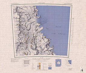
English: Map of Antarctica by the United States Antarctic Resource Center of the US Geological Survey. |
| Dáta | |
| Foinse | USGS |
| Údar | United States Geological Survey |
This image is in the public domain in the United States because it only contains materials that originally came from the United States Geological Survey, an agency of the United States Department of the Interior. For more information, see the official USGS copyright policy.
|
Stair chomhaid
Cliceáil ar dáta/am chun an comhad a radharc mar a bhí sé ag an am sin.
| Dáta/Am | Mionsamhail | Toisí | Úsáideoir | Nóta tráchta | |
|---|---|---|---|---|---|
| faoi láthair | 12:03, 4 Aibreán 2005 | | 3,845 × 3,244 (1.69 MB) | Achim Raschka | Map of Antarctica by the United States Antarctic Ressource Center of the US Geological Society. {{PD-US}} Copyrights and Trademarks USGS-authored or produced data and information are in the public domain. While the content of most USGS web pages is in th |
Úsáid comhaid
Tá nasc chuig an gcomhad seo ar na leathanaigh seo a leanas:
Global file usage
The following other wikis use this file:
- Úsáid ar ar.wikipedia.org
- Úsáid ar ceb.wikipedia.org
- Úsáid ar de.wikipedia.org
- Churchill Mountains
- Nash Range
- Flynn-Gletscher
- Dickey-Gletscher
- Starshot-Gletscher
- Kelly-Plateau
- Surveyors Range
- Beaumont Bay
- Silk-Gletscher
- Jorda-Gletscher
- Kap Parr
- Young Head
- Harris Point
- Nursery-Gletscher
- Darley Hills
- Shackleton-Küste
- Boyer Bluff
- Bridge-Pass
- Brown Buttress
- Deverall Island
- Donnally-Gletscher
- Swithinbank Range
- Kap Laird
- Úsáid ar en.wikipedia.org
- Úsáid ar es.wikipedia.org
- Úsáid ar he.wikipedia.org
- Úsáid ar hu.wikipedia.org
- Úsáid ar it.wikipedia.org
View more global usage of this file.