
Íomhá:Balkan peninsula line.jpg
Níl aon taifeach is mó ar fáil.
Balkan_peninsula_line.jpg (558 × 530 picteilín, méid comhaid: 169 KB, cineál MIME: image/jpeg)
| Seo comhad as An Cómhaoin Viciméid. Tá an tuairisc as an leathanach tuairisc Cómhaoin a leanas thíos.
|
Achoimriú
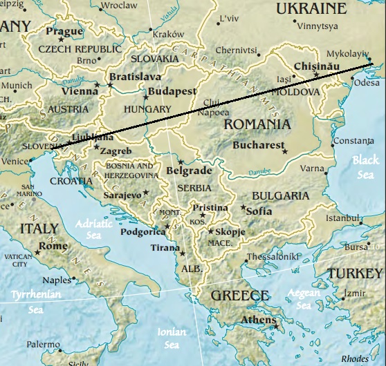
| Tuairisc | Map of the Balkan peninsula, showing the line stretching from the northernmost point of the Adriatic to the northernmost point of the Black Sea. Made from Europe map at The Central Intelligence Agency World Factbook, which is in the public domain. |
| Foinse | https://www.cia.gov/library/publications/the-world-factbook//graphics/ref_maps/physical/jpg/europe.jpg |
| Údar | CIA |
| Leaganacha eile |
|
.jpg)
Ceadúnú
This image is in the public domain because it contains materials that originally came from the United States Central Intelligence Agency's World Factbook.
|
 |

|
This map image could be re-created using vector graphics as an SVG file. This has several advantages; see Commons:Media for cleanup for more information. If an SVG form of this image is available, please upload it and afterwards replace this template with
{{vector version available|new image name}}.
It is recommended to name the SVG file “Balkan peninsula line.svg”—then the template Vector version available (or Vva) does not need the new image name parameter. |


Stair chomhaid
Cliceáil ar dáta/am chun an comhad a radharc mar a bhí sé ag an am sin.
| Dáta/Am | Mionsamhail | Toisí | Úsáideoir | Nóta tráchta | |
|---|---|---|---|---|---|
| faoi láthair | 12:27, 16 Eanáir 2014 | | 558 × 530 (169 KB) | Denniss | Reverted to version as of 22:51, 26 December 2013 |
| 21:21, 15 Eanáir 2014 |  | 348 × 382 (43 KB) | Ivan VA | stop vandalizing maps | |
| 22:51, 26 Nollaig 2013 |  | 558 × 530 (169 KB) | No More Cats | Please don't revert to outdated versions of maps | |
| 22:43, 26 Nollaig 2013 |  | 348 × 382 (43 KB) | Nikola Smolenski | Reverted to version as of 19:13, 3 November 2006 | |
| 16:06, 17 Nollaig 2013 |  | 558 × 530 (169 KB) | No More Cats | Map of the Balkan peninsula, showing the line stretching from the northernmost point of the Adriatic to the northernmost point of the Black Sea. Made from most recent map at [https://www.cia.gov/cia/publications/factbook/reference_maps/jpg/europe.jpg]. | |
| 19:13, 3 Samhain 2006 |  | 348 × 382 (43 KB) | Nikola Smolenski | Map of the Balkan peninsula, showing the line stretching from the northernmost point of the Adriatic to the northernmost point of the Black Sea. Made from map at [https://www.cia.gov/cia/publications/factbook/reference_maps/jpg/europe.jpg]. |
Úsáid comhaid
Níl nasc ó aon leathanach eile don íomhá seo.