
Íomhá:Baginbun Head Map.png
Size of this preview: 800 × 509 picteilín. Other resolutions: 320 × 204 picteilín | 640 × 407 picteilín | 825 × 525 picteilín.
Taispeáin leagan ardtaifigh den íomhá (825 × 525 picteilín, méid comhaid: 41 KB, cineál MIME: image/png)
| Seo comhad as An Cómhaoin Viciméid. Tá an tuairisc as an leathanach tuairisc Cómhaoin a leanas thíos.
|
Achoimriú
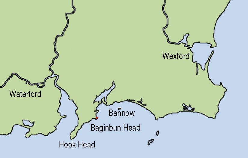
| Tuairisc | Map showing the location of Baginbun Head where Raymond le Gros landed in 1170 in Ireland. Waterford and Wexford were Norse settlements at that time. The first landing of the Normans took place at Bannow Island in 1169. (This island meanwhile joined the mainland.) |
| Dáta | |
| Foinse | This map is based on Image:Topography Ireland.jpg and my own work using Gimp and xfig. |
| Údar | AFBorchert |
Ceadúnú
Is mise sealbhóir cóipchirt an shaothair seo agus foilsím é faoi na ceadúnais seo a leanas:

|
Tugtar cead an doiciméad seo a chóipeáil, a dháileadh agus/nó a mhodhnú faoi théarmaí an Ceadúnas Doiciméadúcháin Saor ó GNU, Leagan 1.2 nó aon leagan níos déanaí a d’fhoilsigh an Fondúireacht Bogearraí Saor in Aisce; gan aon Rannóga Inmheánacha, gan aon Téacsanna Clúdaigh Tosaigh, agus gan aon Téacsanna Clúdaigh Cúil. Tá cóip den cheadúnas san áireamh sa chuid dar teideal Ceadúnas Doiciméadúcháin Saor ó GNU. |
This file is licensed under the Creative Commons Attribution-Share Alike 4.0 International, 3.0 Unported, 2.5 Generic, 2.0 Generic and 1.0 Generic license.
- Is féidir:
- an saothar seo a roinnt – an saothar seo a chóipeáil, a dháil amach, agus a tharchur
- an saothar seo a athmheascadh – an saothar seo a oiriúnú
- Ach amháin má leantar na coinníollacha seo a leanas:
- sannadh – Ní mor creidiúint a thabhairt leis an saothar, faoi mar a shonraigh an údar nó tabharthóir an ceadúnais (ach ná húsáid modh a thugann le fios go thacaíonn sé/sí tú féin nó an úsáid a bhaineann tú as an saothar).
- comhroinn araon – Má athraíonn tú nó síneann tú amach an saothar seo, ní féidir é a dháileadh ach amhaín faoin gceadúnas céanna nó ceann cosúil leis an gceann seo.
Is féidir leat a roghnú an ceadúnas do rogha
Stair chomhaid
Cliceáil ar dáta/am chun an comhad a radharc mar a bhí sé ag an am sin.
| Dáta/Am | Mionsamhail | Toisí | Úsáideoir | Nóta tráchta | |
|---|---|---|---|---|---|
| faoi láthair | 21:23, 3 Nollaig 2007 | | 825 × 525 (41 KB) | AFBorchert | {{Information |Description=Map showing the location of Baginbun Head where Raymond le Gros landed in 1170 in Ireland. Waterford and Wexford were Norse settlements at that time. The first landing of the Normans took place at Bann |
Úsáid comhaid
Tá nasc chuig an gcomhad seo ar na leathanaigh seo a leanas:
Global file usage
The following other wikis use this file:
- Úsáid ar ca.wikipedia.org
- Úsáid ar de.wikipedia.org
- Úsáid ar en.wikipedia.org
- Úsáid ar es.wikipedia.org
- Úsáid ar fr.wikipedia.org
- Úsáid ar id.wikipedia.org
- Úsáid ar nl.wikipedia.org
- Úsáid ar no.wikipedia.org
- Úsáid ar tr.wikipedia.org
- Úsáid ar www.wikidata.org